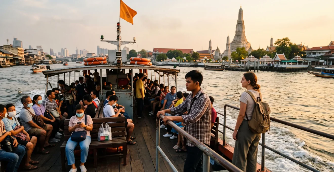
The Chao Phraya River is more than a backdrop for Bangkok’s temples and sunset photographs. It is a working transport corridor connecting historic neighborhoods, commercial districts, ferry crossings and some of Thailand’s best-known cultural landmarks.
For visitors, understanding the river changes how Bangkok is explored. Instead of planning every journey around roads and traffic, travelers can navigate between piers, combine short walks with passenger boats and use inexpensive crossings to reach attractions on opposite banks.
The essential distinction is between commuter express boats, tourist hop-on-hop-off services and small cross-river ferries. Each serves a different purpose, with different routes, operating periods and ticket arrangements. Choosing correctly matters more than simply boarding the first boat that arrives.
Used thoughtfully, the river provides both practical transportation and an introduction to the city’s history: temple roofs, traditional waterfront buildings, working jetties and modern developments appear along the same journey.
Bangkok river transport at a glance
- Plan around piers rather than road distances: Tha Chang, Tha Tien and Wat Arun provide access to important historic attractions.
- Compare commuter express boats with tourist services before buying. The orange-flag fare published for weekdays from 6 October 2026 is 19 THB, but its operating hours and stopping pattern must be checked.
- Use daylight services for practical sightseeing, cross-river ferries for short transfers and carefully timed journeys for sunset photography.
- Why Bangkok’s Temples, Markets, and Palaces All Face the River: The Water-Based City Explained
- How to Visit 6 Bangkok Riverside Temples in 4 Hours Using Express Boats, Not Taxis
- Tourist Dinner Cruise or Local Express Boat: Which Shows You Real River Life?
- The River Boat Mistake That Costs Tourists Far More Than Locals Pay for the Same Route
- When to Ride the Chao Phraya for Golden Hour: Timing the Best Light on the Water
- How to Recognize Thailand’s 4 Regional Cultures Through What You See From the River
- How to Reach the Best Wat Arun Photo Position: The Cross-River Ferry Photographers Use
- How to Photograph Wat Arun at Dawn: The Quiet-Hour Advantage Explained
Why Bangkok’s Temples, Markets, and Palaces All Face the River: The Water-Based City Explained
Bangkok’s major historic landmarks cluster around the Chao Phraya because waterways originally carried people, goods and commercial activity through the city. Before modern road transport, riverside access was valuable for settlement, trade and public life. Today, that inherited geography makes passenger boats a practical way to explore the historic center.
Understanding Bangkok as a water-based city explains features that can otherwise seem confusing on a street map. Important destinations sit close together in river terms, even when reaching them by road requires navigating busy junctions, indirect routes or bridges.
The Creative Economy Agency‘s historical profile of Bangkok describes a city where homes once faced rivers and canals, with everyday movement and trading activities conducted on waterways and rafts. As roads expanded, some canals lost their transport function or were filled to accommodate urban development.
The remaining riverfront reveals this older orientation. The Grand Palace complex and Wat Pho occupy the eastern-bank historic district, while Wat Arun stands across the water on the western bank. Short ferry crossings connect areas that can be inconvenient to reach by road.
These relationships are especially useful when navigating the bends of the Chao Phraya. A destination that appears nearby geographically may be separated by water, while a short boat journey can eliminate a substantial road detour.
1,682 canals
Thailand’s Creative Economy Agency reports 1,682 canals totaling 2,604 kilometers within Bangkok. These historical and geographical figures have no identified measurement date and do not indicate that every canal remains navigable.
Creative Economy Agency, Bangkok city profile.
The khlongs, or canals, once formed a secondary network feeding into the Chao Phraya. Some continue to support boat movement, while others have become narrow neighborhood waterways or disappeared beneath roads. Their remaining banks help explain why older communities often face water rather than modern streets.
This history offers a useful planning rule: identify the nearest functioning pier before selecting a road transfer. Pier locations, rather than straight-line distances, determine whether the river is genuinely convenient.
Once the geography makes sense, the next challenge is turning that knowledge into an achievable temple itinerary without assuming every boat serves every pier.
How to Visit 6 Bangkok Riverside Temples in 4 Hours Using Express Boats, Not Taxis
Visiting six Bangkok riverside temples in four hours requires short visits, careful pier selection and minimal waiting between boats. The most practical approach is to group nearby temples, walk between attractions within the same district and use riverboats for longer transfers or crossings. Four hours is a fast-paced sightseeing target, not a guaranteed comprehensive tour.
Start by distinguishing the two relevant transport systems. The Chao Phraya Express Boat‘s official routes and fares identify commuter services by flag color, while the separate tourist service offers a visitor-oriented stopping pattern.
The commuter operator’s information effective 6 October 2026 identifies the orange-flag route between Nonthaburi and Rajsingkorn as a Monday-to-Friday service charging 19 THB. Other weekday services use yellow, green-yellow and red flags. These boats should not be treated as interchangeable: their operating periods and stopping patterns differ.
For travelers unfamiliar with the network, the tourist route may be easier to navigate. The operator advertises departures approximately every 30 minutes, including stops at Wat Arun, Tha Tien, Tha Chang and other major visitor piers.
A six-site route can be organized around three geographical groups rather than six separate boat journeys. The following is a hypothetical fast-paced itinerary, not a verified four-hour journey or a promise that every temple will be open simultaneously.
Example: six temple stops grouped by river access
- Wat Pho: Begin in the historic district near Tha Tien, allowing approximately 35 minutes for a selective visit.
- Wat Phra Kaew: Continue to the Grand Palace complex for an abbreviated visit, allowing approximately 55 minutes only if entry arrangements and visitor access permit.
- Wat Mahathat Yuwaratrangsarit: Continue within the historic district, allocating approximately 20 minutes.
- Wat Arun: Reach the opposite bank by an appropriate cross-river connection and allow approximately 35 minutes.
- Wat Kalayanamit: Continue south on the western side using a separately verified local transfer, allowing approximately 20 minutes.
- Wat Prayurawongsawat: Finish with approximately 20 minutes, using walking or a verified onward connection.
The suggested visits total 185 minutes. That leaves 55 minutes within a four-hour window for all walking, waiting, ticketing and river transfers. Because those transfers have not been validated against a complete timetable, the itinerary is ambitious and may not be feasible as scheduled.
The Grand Palace is particularly important to schedule early. Its official visitor information lists opening hours of 8:30 AM to 4:30 PM, ticket sales until 3:30 PM and admission at 500 THB. A strict dress code applies. These arrangements cannot be assumed to apply to the other temples.
Before attempting the full route, check the precise pier serving each required direction. A commuter boat does not necessarily stop wherever a tourist boat stops, and a cross-river shuttle is not the same service as a boat traveling along the river.
Six short stops prioritize the number of temples reached over time spent understanding them. Visitors interested in architecture, ceremonies or photography will often gain more from three or four longer visits.
Five checks before starting a temple-by-boat itinerary
- Mark each temple and its nearest usable pier on a map. Deliverable: a six-stop location sequence.
- Check the operating day and stopping pattern of each planned boat. Deliverable: a verified route and direction for every river transfer.
- Confirm opening hours and admission requirements for every temple. Deliverable: a list of permitted visiting windows.
- Allocate time separately to visits, walking and boat waiting. Deliverable: a timetable with a realistic transfer allowance.
- Identify a shorter alternative that skips two sites if delays occur. Deliverable: a four-temple backup route.
Once the route is established, the choice of vessel becomes a question of experience as well as transportation: commuter services and leisure cruises reveal very different versions of Bangkok.
Tourist Dinner Cruise or Local Express Boat: Which Shows You Real River Life?
A local express boat is the better choice for observing Bangkok’s everyday river transport, while a dinner cruise is designed around sightseeing, hospitality and illuminated waterfront views. The experiences are not interchangeable. Commuter boats reveal how people move through the city; cruises provide more time to admire the skyline without arranging individual transfers.
On an express boat, the journey itself is functional. Passengers board and leave at working piers, boats maintain their scheduled direction and scenery changes as the vessel moves between neighborhoods. The experience is shaped by the transport network rather than a sightseeing commentary.
A dinner cruise presents a different perspective. Passengers remain aboard for a leisure journey, usually prioritizing seated comfort, food and nighttime views. Its value depends on the actual route, seating arrangements, weather conditions and what is included in the booking.
The practical differences are easier to compare side by side.
| Criterion | Local express boat | Tourist dinner cruise |
|---|---|---|
| Primary purpose | Public transport | Leisure and dining |
| River perspective | Working piers and daily movement | Waterfront scenery and illuminated landmarks |
| Stops | Designated passenger piers | Usually a planned cruise without intermediate sightseeing stops |
| Flexibility | Individual journeys can be combined with walking and visits | Passengers generally follow the booked cruise schedule |
| Cost structure | Published transport fares | Package prices and potentially additional charges |
| Best use | Daytime exploration and functional mobility | Evening leisure and waterfront views |
Timing matters almost as much as boat type. A weekday commuter service can reveal a different rhythm during busy travel periods than during quieter departures. The presence of local passengers, however, should not be interpreted as a guaranteed cultural performance: people are simply traveling.
For a balanced visit, use passenger boats when moving between attractions during the day. Consider an evening cruise separately if seated comfort, dinner and a longer uninterrupted view justify the additional expense.
Before booking any cruise, verify the exact departure pier rather than assuming all operators leave from the same terminal. Check the scheduled return point, boarding time, deck access, assigned seating, cancellation conditions and whether meals or drinks carry supplements.
A cruise may be attractive to visitors with limited mobility or those avoiding repeated boarding, but accessibility arrangements still require confirmation with the specific operator. Express boats can involve moving platforms, steps and crowded boarding areas.
For short heritage journeys, the next distinction is financial: a boat marketed to tourists may cover similar river territory to a considerably cheaper commuter service.
The River Boat Mistake That Costs Tourists Far More Than Locals Pay for the Same Route
The costly mistake is buying a tourist boat ticket without checking whether an ordinary express boat serves the required journey. Tourist boats and commuter vessels can cover overlapping sections of the Chao Phraya, but their fare structures and stopping patterns differ. A higher price may buy flexibility or convenience rather than access to a completely different river.
The clearest verified commuter benchmark is the orange-flag fare published by Chao Phraya Express Boat for its service effective 6 October 2026: 19 THB per journey on the specified weekday route between Nonthaburi and Rajsingkorn.
The same information identifies other weekday express services: yellow-flag boats at 24 THB, red-flag boats at 33 THB and green-yellow services with fares varying by route section, from 17 to 36 THB.
These are operator-specific fares, not a universal price schedule for every boat on the river. The tourist boat’s available service description does not establish a verified October 2026 ticket price, so an exact tourist-to-local fare multiplier cannot responsibly be stated.
To make an informed choice, first identify the boarding pier and destination. Then check whether a commuter route currently serves both stops, whether it operates on the intended day and whether its timetable matches the visit.
Only after those checks should the ticket prices be compared. A tourist day pass may make sense for multiple eligible journeys, but it is unnecessary for someone taking a single inexpensive local trip.
Illustrative fare calculation
Suppose a traveler plans three eligible journeys on a weekday orange-flag service, each charged at the published 19 THB flat fare. The total commuter fare would be 57 THB.
A tourist pass would need to be compared with that 57 THB total, considering whether it covers the same stops and provides useful additional operating hours. This is a hypothetical calculation, not a verified comparison with a current tourist-pass price.
At the pier, inspect the destination and boat identification instead of relying on the ticket seller’s description of a generic river tour. Check the displayed flag, route information and the correct fare or official ticket counter. Payment arrangements may vary by service and boarding location.
Another potential source of unnecessary expense is accepting an unsolicited private-boat offer without checking the public transport alternatives. A longtail boat is a different service, and its price should be agreed upon only after confirming the route, duration, passenger capacity and total cost.
Official piers and operator information are the best starting points for avoiding misunderstandings. A private journey should be a conscious purchase, not the result of assuming ordinary public boats are unavailable.
Once a suitable service is selected, the journey can be timed for scenery rather than merely scheduled around the next available departure.
When to Ride the Chao Phraya for Golden Hour: Timing the Best Light on the Water
Late afternoon is an effective time to experience the Chao Phraya because the lowering sun creates warmer light, changing reflections and more atmospheric views of riverside buildings. The best departure is determined by the actual sunset, the direction of travel and the boat’s final operating time, not a fixed 5 PM departure.
The river changes direction around Bangkok’s bends, so there is no single side of the vessel that guarantees sunlight on every landmark. Wat Arun occupies the western bank, while many familiar viewpoints toward its central prang are on the eastern bank. The sunset can therefore produce striking silhouettes rather than straightforward front lighting.
Travelers seeking warm architectural detail should observe the sun’s position relative to their chosen viewpoint. Those seeking silhouettes and reflective compositions can make deliberate use of backlighting.
A practical strategy is to travel upriver while daylight remains, then return on an available downstream service as the skyline moves toward dusk. This is a planning approach, not a guaranteed round trip: the return schedule must be verified before departure.
The Chao Phraya Tourist Boat‘s official service information describes approximately 30-minute departures and an evening extension toward Asiatique. However, the published general description does not establish a complete last-departure timetable for every pier.
Likewise, the presence of an evening tourist service does not mean that weekday commuter express routes continue operating throughout the evening. A traveler using an orange-flag boat earlier in the day should not assume it will be available for the return journey after sunset.
For an adaptable photography outing, plan three phases:
- Board during daylight, allowing time to identify temple positions and potential viewpoints.
- Use the late-afternoon light for riverside architecture, boats and layered scenes along the banks.
- Finish near a pier with a verified onward transport option before committing to photographs after dark.
Golden-hour light also changes with the season, weather and haze. Cloud cover may soften contrasts or obscure the sunset entirely, while a clear evening can produce stronger silhouettes and sharper reflections.
On an overcast evening, illuminated temples and their reflections can remain worthwhile photographic subjects after the sky darkens. This may require photographing from a fixed riverside location rather than relying on an operating express boat.
A commuter journey can be repeated economically when the route and timetable suit the outing. That flexibility makes it possible to enjoy one afternoon as transport and another as an unhurried photography opportunity.
The waterfront also reveals another aspect of Bangkok beyond its landmarks: a city shaped by communities and cultural traditions from across Thailand.
How to Recognize Thailand’s 4 Regional Cultures Through What You See From the River
Thailand’s four commonly recognized cultural regions—North, Northeast or Isaan, Central and South—can be explored through Bangkok’s food, community traditions and religious life. The riverfront offers useful opportunities to encounter these influences, but a passing boat cannot reliably identify every region through temple architecture or a single waterfront scene.
Bangkok is a cultural crossroads rather than a miniature exhibition of four neatly separated traditions. Its communities reflect migration, commerce and political history, including influences from neighboring countries and longstanding Chinese, Mon, Muslim and other populations.
Along the Chao Phraya, this diversity is most clearly appreciated by combining river transport with stops at markets, neighborhoods and places of worship. The water provides the route; closer observation on land provides the cultural context.
These examples offer a starting vocabulary for recognizing regional influences without treating every dish or building as proof of a particular community’s origins.
| Region | Useful cultural clue | How to explore it responsibly |
|---|---|---|
| North | Northern Thai food and distinctive Lanna artistic traditions | Look for clearly identified regional dishes or cultural exhibits rather than assuming a riverfront temple is Northern. |
| Northeast (Isaan) | Som tam and other Northeastern food traditions | Explore food stalls around accessible markets and ask about regional preparation styles. |
| Central | Bangkok’s royal and riverside Buddhist heritage | Observe the historic temple and palace landscape while recognizing influences beyond a single region. |
| South | Southern Thai and Muslim-associated food traditions | Seek out identifiable community food establishments and understand that Muslim culinary traditions are not exclusive to Southern Thailand. |
Som tam, a papaya salad strongly associated with Northeastern Thailand, and roti associated with Muslim culinary traditions are examples of how regional food cultures appear in Bangkok. Their presence illustrates cultural exchange, not necessarily the regional identity of the person preparing them.
For direct river-related cultural observation, the Central Thai historical landscape is especially accessible. Temples, royal architecture and established waterfront communities demonstrate the Chao Phraya’s role in the development of Bangkok.
Riverside neighborhoods around Ratchawongse and the historic commercial areas also provide opportunities to observe the city’s multicultural history. Their Chinese-influenced commercial heritage adds an important dimension that does not fit neatly into Thailand’s four-region classification.
Seasonal festivals reveal different relationships with the water. Loi Krathong, associated with floating offerings on waterways, remains an example of Bangkok’s water-related traditions. Visitors should confirm the dates and designated participation areas rather than assuming celebrations occur identically at every pier.
Early-morning religious activity can also offer glimpses of neighborhood routines, although a monk traveling by boat or receiving offerings should not be represented as a guaranteed sight on any particular route.
The most reliable approach is to listen, read local interpretation and identify dishes or traditions through their actual descriptions. Roof shapes alone are not a dependable way to classify four regional cultures from a moving boat.
For travelers interested in a specific landmark rather than a broader cultural survey, Wat Arun offers a useful example of how river crossings and viewpoint selection shape the experience.
How to Reach the Best Wat Arun Photo Position: The Cross-River Ferry Photographers Use
The classic river-facing photographs of Wat Arun are usually made from the eastern bank of the Chao Phraya, opposite the temple. The short ferry crossing between the Tha Tien area and Wat Arun helps visitors move between the historic district and the temple’s western-bank location. The best bank depends on whether the goal is to photograph Wat Arun from across the river or explore it up close.
Geography matters here because the temple itself stands on the western bank. Boarding a ferry at Tha Tien on the eastern side generally takes travelers toward Wat Arun, not toward the opposite-bank viewpoint from which the entire temple can be framed across the water.
For the familiar wide composition featuring the central prang and the river in the foreground, remain on the eastern side and look for a lawful, publicly accessible riverside viewpoint around the Tha Tien area. If already visiting Wat Arun, the return ferry can be useful for reaching that opposite-bank perspective.
Choose the location based on three photographic considerations: the amount of river visible in front of the temple, obstructions from buildings or moored vessels, and whether the central prang remains distinguishable from surrounding structures.
Stepping farther back can improve the architectural composition, but usable access depends on the exact waterfront property and any restrictions imposed by businesses or pier operators. Some views may be available only from commercial premises.
A short ferry crossing is normally a more practical way to change banks than hiring a private boat solely for a temple photograph. However, the supplied transport information does not verify the current independent ferry fare or operating schedule, so an exact low-price claim should not determine the plan.
The separate tourist boat service also lists Wat Arun and Tha Tien among its destinations, but it should not be confused with a dedicated cross-river shuttle. Confirm which service is being boarded, particularly when purchasing tickets at a busy pier.
Wat Arun is frequently photographed around sunset because its distinctive tower can be silhouetted against the evening sky. Viewpoint popularity and exact crowd density vary, so it is wise to choose a legal standing position before setting up a tripod or other equipment.
Water levels and moving vessels can change the foreground composition. A small ferry crossing the frame may provide scale, but it can also block an architectural detail at the moment of exposure.
For nighttime photographs, confirm the last available crossing and prepare an alternative return route. Evening illumination of a landmark does not establish that the nearby ferry will still be operating.
Sunset provides one familiar interpretation of the temple, but dawn can create a quieter visual experience with different lighting and transport constraints.
Key takeaways before photographing Wat Arun at dawn
- For photographs of Wat Arun across the water, identify an accessible eastern-bank viewpoint rather than automatically crossing to the temple.
- Check dawn light against actual sunrise and boat operating times; a good photography window does not guarantee an available ferry.
- Choose the morning for quieter observational photography and the evening for silhouettes or illuminated architecture, depending on conditions.
How to Photograph Wat Arun at Dawn: The Quiet-Hour Advantage Explained
Photographing Wat Arun at dawn offers the possibility of softer light, fewer sightseeing crowds and atmospheric views of the Chao Phraya before the busiest daytime activity begins. The critical logistical distinction is that sunrise may occur before convenient tourist boat departures. A successful early-morning shoot therefore starts with the viewpoint and transport plan, not an assumed ferry schedule.
From the eastern bank, Wat Arun’s central prang can be photographed across the water as daylight develops. Because sunrise occurs toward the east, this viewpoint offers a different lighting relationship from the familiar sunset silhouette. Depending on season and the precise position of the camera, sunlight may illuminate parts of the temple while the surrounding sky grows brighter.
The river itself provides a natural foreground. Moving boats, ripples and reflections can create depth without requiring close access to the monument.
Early mornings may also bring haze or mist, although these conditions are weather-dependent rather than assured. During cloudier periods, the strongest photographs may emphasize tonal separation between the temple, water and sky rather than direct sunlight.
A workable dawn photography plan follows a simple sequence:
- Identify a publicly accessible eastern-bank location the previous day, verifying whether it can be entered before sunrise.
- Check the local sunrise time for the exact date and plan to reach the viewpoint before the desired light develops.
- Confirm available early transport independently rather than relying on tourist boat frequency information that does not establish the first departure.
- Begin with wider compositions showing the river, then experiment with architectural details as visibility improves.
- Reserve a later boat journey for visiting Wat Arun itself if the temple and transport schedules permit.
For camera settings, prioritize a stable shutter speed when photographing moving vessels. In low light, a higher ISO may be preferable to motion blur if working without a tripod.
When the sky is much brighter than the temple, expose carefully to retain highlight detail and review the image before adjusting. A silhouette can be effective, but it should be an intentional choice rather than an accidental result of automatic exposure.
A fixed position also allows slower, more deliberate framing than shooting from a moving passenger boat. This is particularly useful for balancing the central prang against the river horizon and surrounding buildings.
The first visible activity on the river may include working boats, local passengers and religious movement, but none should be treated as a guaranteed photographic event. Respect people carrying out their daily routines and avoid obstructing boarding areas.
Compared with sunset, dawn can provide a quieter atmosphere but requires greater preparation. Evening sightseeing services may be easier to coordinate with tourist itineraries, while sunrise photography often depends on independently arranged access and transportation.
Choose a dawn viewpoint, verify how to reach it, photograph the changing light and then continue exploring Bangkok by boat when the appropriate passenger services begin operating. The Chao Phraya becomes most useful when its scenic possibilities and transport limitations are planned together.
Can visitors use Bangkok’s commuter riverboats without booking a tour?
Yes. Chao Phraya Express Boat services function as passenger transport rather than exclusively guided sightseeing experiences. Visitors should check the relevant route, service day, operating hours, destination pier and ticket arrangements before boarding. Not every commuter boat stops at every tourist attraction.
Do orange-flag express boats operate on weekends?
The operator’s published route information effective 6 October 2026 identifies the orange-flag service between Nonthaburi and Rajsingkorn as operating Monday to Friday. Do not plan a weekend journey around that service without checking for an updated schedule. The tourist boat is a separate operation with its own timetable.
Which Chao Phraya pier is useful for visiting the Grand Palace?
Tha Chang is a useful pier for accessing the Grand Palace area. The historic district also contains Wat Pho, near Tha Tien, allowing visitors to combine walking with river transport. Check the relevant boat’s stopping pattern and the palace’s admission requirements before traveling.
Is a Chao Phraya tourist boat day pass always cheaper than individual tickets?
No. The better value depends on the current pass price, the number of journeys, the required stops and whether an alternative commuter route is available. For example, three eligible journeys at the published orange-flag fare of 19 THB would total 57 THB. That total should be compared with the actual tourist ticket price and service conditions before purchasing.
Can Wat Arun be photographed before the tourist boats start running?
Potentially, provided an appropriate riverside viewpoint is publicly accessible at that hour and alternative transport is available. Tourist boat departure information does not establish access to every viewpoint before sunrise. The eastern bank is generally the useful side for framing Wat Arun across the river, while the temple itself is on the western bank.