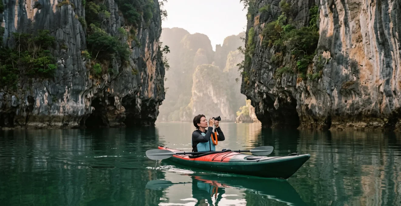
The most effective position for photographing Phang Nga Bay‘s limestone towers is often not a tour-boat deck. It is a stable kayak floating near water level, far enough from a cliff to capture its height and close enough to use its textures, overhangs and reflections as compositional elements.
The difference is perspective. A large tour boat can deliver impressive panoramic views, but its height, movement and fixed itinerary limit where a photographer can frame a cliff face or wait for undisturbed water. A sea kayak offers finer positional control and, where access is permitted and conditions are safe, a route into narrow channels and enclosed lagoons.
That flexibility does not eliminate tidal restrictions, boat traffic or weather. Sea caves can become inaccessible, and a kayak cannot safely approach every rock wall. Successful photography therefore depends on matching a specific composition to the right light, water conditions and access method rather than assuming that getting closer always produces a better image.
Phang Nga Bay kayak photography: the essentials
- Use a low camera position and sufficient distance from the cliffs to combine towering limestone walls, water reflections and a recognizable sense of scale.
- Plan cave and hidden-lagoon visits around locally confirmed tidal access windows, with camera equipment secured during passages.
- Favor calm early-morning or late-afternoon conditions and small-group kayak access when composition and shooting time matter more than covering numerous attractions.
- Why Phang Nga Bay Has Vertical Rock Towers: The 280-Million-Year Geological Story
- How to Access Phang Nga’s Hidden Lagoons: The Low-Tide Kayak Timing
- Phang Nga Bay vs Ha Long Bay: Which Karst Landscape Is Worth the Journey?
- The Phang Nga Tour That Ruins Photos: Why 40-Person Longtails Beat the Purpose
- When to Visit Phang Nga Bay for Blue Skies and Calm Water: The Post-Monsoon Window
- How to Access Phang Nga’s Hidden Lagoons: The Low-Tide Kayak Timing
- When to Visit Phang Nga Bay for Blue Skies and Calm Water: The Post-Monsoon Window
- How to Access Railay Peninsula: The Boat-Only Journey From Ao Nang and Krabi Town
Why Phang Nga Bay Has Vertical Rock Towers: The 280-Million-Year Geological Story
Phang Nga Bay’s limestone towers are the visible result of a long geological history involving ancient carbonate deposits, changes in land and sea levels, and prolonged limestone dissolution and erosion. These processes created steep walls, undercut bases and caves that make the landscape particularly striking from a kayak. The commonly cited 280-million-year geological story should not, however, be treated as an exact age for every formation.
Limestone originates from calcium carbonate deposits, often associated with ancient marine environments and biological material. Across geological time, burial, tectonic processes, exposure and the movement of water can transform these deposits into the distinctive landforms known as karst.
Rainwater and groundwater gradually dissolve susceptible limestone along fractures and other pathways. Marine erosion can further modify exposed coastal surfaces. The result is an irregular landscape of cliffs, caves, notches and isolated rock masses.
According to the Tourism Authority of Thailand‘s Phang Nga destination page, the national park features limestone formations rising vertically from the sea, islands and submerged caverns. Its sheltered waters also make sea kayaking a suitable way to explore the landscape.
For photographers, the geological structure creates three useful compositional elements:
- Vertical walls: frame a tower with a small kayak or distant vessel to communicate its height without relying on an exaggerated wide-angle perspective.
- Rock textures and vegetation: use dark weathering patterns, cracks and horizontal vegetation boundaries to create visual rhythm across the cliff.
- Undercut bases: include the boundary between rock and water to emphasize how a formation appears to emerge directly from the bay.
Many prominent cliff sections provide no convenient beach foreground. This makes reflected shapes, ripples, exposed rock and neighboring towers more useful than conventional land-based foreground objects. A water-level camera position can also reveal the contrast between a dark overhang and the brighter open water.
The same geological processes that create striking cliff profiles also help explain the bay’s cave entrances. These features offer alternative photographic viewpoints, but they require separate access and safety planning.
Understanding why the rock walls have their present shape makes it easier to recognize promising angles from the water. Reaching the most enclosed compositions, however, depends on tides as much as geology.
How to Access Phang Nga’s Hidden Lagoons: The Low-Tide Kayak Timing
Phang Nga Bay’s hidden lagoons, often called hongs, may be accessible by kayak through tidal sea caves, but entry conditions differ between locations. Some passages become navigable only when water levels are sufficiently low, while others have different local access windows. Photographers should confirm the specific cave’s tide requirements, weather conditions and safe exit arrangements with an experienced local operator before entering.
A hong can provide an unusual photographic setting: enclosed water surrounded by high limestone walls, with light entering from above. The effect differs from the open bay because the enclosing cliffs restrict the visible sky and create strong contrasts between illuminated vegetation and shaded rock.
The Thailand Tourism Directory listing for Tham Lod cave provides a documented example of tidal access in Phang Nga Province. It describes a cave passage navigable by small boats only at low tide. This condition applies to that named cave and should not be generalized into a universal entry threshold for every hong.
A tide table is a planning input, not an entry permit. Predictions for the relevant locality need to be combined with direct assessment of the cave entrance, current water levels, available clearance, wind and the return route. The exact safe window may vary from one passage to another.
Some low entrances require passengers to recline or lie nearly flat. This is not a passage to attempt while handling an exposed camera. Pack the camera and spare equipment in secured waterproof bags before approaching the entrance, then unpack only after the kayak has reached a safe position where conditions permit.
Whether a photographer should paddle independently or join a guided excursion depends on far more than kayaking experience. Familiarity with tides, confined passages, local routes and applicable park rules matters more than confidence on open water.
| Decision factor | Independent kayak | Guided kayak |
|---|---|---|
| Local cave knowledge | Requires reliable firsthand route knowledge and independently confirmed access | Local route assessment can be provided by the operator |
| Tidal planning | Photographer must establish a safe entry and exit window | Guide should explain the passage-specific tidal limits |
| Restricted areas | Access must be confirmed with the relevant park authority | Operator should confirm permissions and applicable guide requirements |
| Photography control | More flexibility where independent access is permitted | Depends on group size, conditions and itinerary |
| Confined passage risk | Not suitable without specific competence and appropriate safety support | Prefer an experienced guide; passage must still be safe |
The essential safety principle is to maintain a confirmed return route throughout the visit. An incoming tide can reduce cave clearance or close an exit. Even on a falling tide, do not enter an unfamiliar passage without local confirmation that the complete route and return window are safe. If clearance, visibility or conditions are uncertain, do not enter.
Once safely inside an accessible lagoon, prioritize the contrast between open sky and shaded limestone rather than rushing through multiple viewpoints. The quiet, enclosed composition is the reward for careful access planning.
Phang Nga Bay vs Ha Long Bay: Which Karst Landscape Is Worth the Journey?
Choose Phang Nga Bay if your main goal is intimate, kayak-level photography of coastal limestone walls, sheltered channels and accessible sea caves. Choose Ha Long Bay–Cat Ba Archipelago if you want to explore an extensive marine karst landscape with opportunities for layered island compositions. Neither destination automatically guarantees better light, fewer visitors or easier kayak access; the deciding factor is the kind of image and trip experience you want.
The two landscapes share important geological characteristics. Both contain limestone formations shaped by long-term karst processes and interaction with marine environments. Their photographic possibilities nevertheless depend on local geography, boat routes and the particular area visited.
The UNESCO World Heritage description of Ha Long Bay–Cat Ba Archipelago identifies the combined property as an extensive example of marine-invaded tower karst, with limestone pillars, sheer cliffs, vegetated islands, caves and marine lakes.
1,133 islands and islets
UNESCO’s figure for the combined Ha Long Bay–Cat Ba Archipelago World Heritage property, which covers 65,650 hectares. These figures describe the present combined property, not Phang Nga Bay or the historical Ha Long Bay boundaries alone.
UNESCO World Heritage Centre
For a photographer, the relevant comparison is not simply how many towers exist. It is how easily the chosen itinerary allows you to control distance, framing and light.
| Photography priority | Phang Nga Bay, Thailand | Ha Long Bay–Cat Ba, Viet Nam |
|---|---|---|
| Primary composition | Close cliff studies, water-level perspectives and enclosed coastal scenes | Island groupings, marine panoramas and layered limestone scenery |
| Kayak access | Established sea-kayaking excursions, with cave access dependent on conditions | Kayaking is available in designated areas and on suitable itineraries |
| Typical travel gateway | Phuket, Phang Nga or the Krabi region | Hanoi, then onward travel toward the bay |
| Seasonal decision | Consider Andaman Sea conditions and monsoon exposure | Consider northern Viet Nam’s seasonal weather, visibility and temperatures |
| Tour limitation | Fixed boat routes may restrict stops and camera positions | Cruise routes and activity schedules may restrict flexibility |
A claim that Ha Long Bay is unsuitable for kayaking would be misleading. Kayak activities exist there, although access varies by location and operator. Similarly, Phang Nga does not guarantee freedom to paddle everywhere inside protected areas.
For a short trip already centered on Phuket, Phang Nga may involve simpler logistics. For a journey already passing through Hanoi, Ha Long Bay–Cat Ba may be a more natural addition. Compare complete transport arrangements, approved kayaking locations and the amount of uninterrupted shooting time, rather than headline tour prices alone.
Both destinations can experience congestion around popular landmarks. The useful advantage is not an absence of visitors but the ability to choose a quieter composition away from the busiest viewpoints when the route permits it.
Whichever destination you choose, confirm what the boat itinerary actually allows. A beautiful marine landscape cannot compensate for a schedule that leaves no opportunity to position the camera.
The Phang Nga Tour That Ruins Photos: Why 40-Person Longtails Beat the Purpose
A crowded, fixed-itinerary longtail tour can undermine a Phang Nga Bay photography trip when it places photographers at busy viewpoints during harsh light and offers little control over stopping distance or camera angle. The problem is not the longtail boat itself or a particular passenger count. It is the mismatch between sightseeing logistics and the patience needed for deliberate landscape compositions.
Tour boats are useful for reaching major areas of the bay and can provide excellent elevated viewpoints. But a vessel serving many passengers must balance photography against transport, sightseeing and scheduled stops. A photographer may have only a brief opportunity to shoot before the boat moves again.
Water movement is another constraint. Passing boats can create wake that disturbs potential reflections. Once the water begins to ripple, the mirrored outline of a limestone tower becomes fragmented, especially when photographed with a longer focal length.
A kayak offers a different method: move into an appropriate, permitted location, stop paddling, allow the water and camera to settle, then compose the image from near the surface.
Consider three practical framing approaches. First, place the camera low and frame a dark overhang against its reflection, leaving enough room for the mirrored rock shape. Second, move farther from the tower to preserve the full vertical profile rather than exaggerating its base with an excessively close wide-angle view. Third, include a distant vessel or kayak in the frame as a scale reference, provided it does not overwhelm the composition.
Kayak height alone does not guarantee a reflection. Wind, currents, boat traffic, paddling movement and the angle of the light can all prevent a clean mirror effect. A kayak also becomes less stable when the photographer twists or leans excessively, so compositions must remain compatible with safe seating and balance.
Choose the tour by the access it provides, not merely by whether kayaking is advertised. Ask about group size, departure time, time spent paddling, whether the route includes protected channels, and how the operator handles tides and unfavorable conditions.
Five checks before booking a photography-focused kayak tour
- Request the planned departure and return schedule, and save a written itinerary showing potential photography periods.
- Ask how many guests share each kayak group, and record the maximum group size provided by the operator.
- Confirm the specific kayaking areas and cave stops, and obtain a route or named-location list rather than a generic bay description.
- Ask who evaluates tides, weather and permitted access, and retain the operator’s explanation of the safety procedure.
- Verify whether the itinerary allows pauses for composition, and obtain a clear answer about photography time and any flexibility available.
Independent rental and paddling permissions should be confirmed locally rather than assumed. Some protected or managed locations may limit access, and the available source material does not establish a universal prohibition on independent kayaking throughout the national park.
A guided small-group excursion can preserve important control over framing, pace and position without giving the photographer complete freedom over routes or departure times. That compromise is often preferable to attempting an unfamiliar passage without local knowledge.
The best photographic excursion is the one that offers enough flexibility to wait for an image while preserving the safety and access constraints of the bay.
When to Visit Phang Nga Bay for Blue Skies and Calm Water: The Post-Monsoon Window
For better chances of blue skies, calmer water and dependable kayaking conditions in Phang Nga Bay, plan around the generally drier northeast-monsoon period, commonly associated with approximately November through April on Thailand’s Andaman coast. Conditions still vary, especially around seasonal transitions. For photography, the hour of the day matters as much as the month: soft directional light and calm water are more valuable than a clear midday sky alone.
The Andaman coast experiences contrasting seasonal influences. The southwest monsoon generally brings a greater likelihood of rain, rougher seas and weather-related disruptions, while the northeast-monsoon period is typically more favorable for many coastal excursions.
These seasonal patterns affect the probability of favorable conditions, not the exact appearance of the bay on a particular day. A clear forecast does not guarantee flat water, and a cloudy morning can still produce visually compelling cliffs.
Morning and late-afternoon light often reveals more surface texture than overhead midday illumination. When the sun reaches the rock from the side, fissures, vegetation and undercut limestone sections cast shadows that help define the cliffs’ volume.
Midday light can flatten the appearance of exposed surfaces and create harsh brightness differences between the sky and dark rock. Nevertheless, it may be useful for certain enclosed lagoon photographs where the overhead opening admits light that is unavailable earlier or later.
For reflection-based compositions, evaluate the actual water surface rather than relying exclusively on the weather forecast. Even modest wind or passing vessels may disturb reflections, while a sheltered channel can remain photographically useful when more exposed areas are rippled.
Tropical humidity and atmospheric haze introduce another consideration. Distant towers may appear low-contrast even on apparently fair-weather days. Instead of attempting to recover every detail through heavy editing, use a longer focal length to build layered silhouettes, or move to a closer composition where rock texture remains distinct.
The beginning of the drier period can still produce unfavorable sea states or rain. Photographers who prioritize caves and enclosed lagoons should allow schedule flexibility, because the most desirable itinerary may not operate safely on the chosen day.
Season determines the likelihood of suitable conditions; the daily forecast, tides and actual light determine which photographs are possible. Keeping a flexible shooting window is more useful than expecting any calendar month to guarantee perfect reflections.
How to Access Phang Nga’s Hidden Lagoons: The Low-Tide Kayak Timing
To time a hidden-lagoon photography visit, identify the intended sea cave, confirm its locally approved access window and arrange a safe return before entering. Low tide is essential for some passages, but the lowest predicted tide is not a universal target for every hong. The correct timing depends on entrance clearance, water movement, local knowledge and the applicable access restrictions.
Consider a hypothetical photography outing arranged around an enclosed lagoon. The photographer wants a frame containing a dark limestone wall, bright vegetation near the rim and the reflection of the opening on the water. A conventional sightseeing schedule may allocate only a short stop, regardless of whether the entrance is navigable at that moment.
A photography-focused plan begins with the location rather than the departure time. The operator identifies the desired lagoon, evaluates the relevant tide predictions and decides whether the route can be entered and exited safely under the expected conditions.
This process should not be reduced to subtracting a fixed number of minutes from low tide. A published prediction does not account for every local obstruction or change in sea state, and the available evidence does not establish a safe water-height threshold applicable across the bay.
Hypothetical example: organizing one lagoon photograph
A photographer asks a qualified local operator to plan an excursion to a specific hong. The operator confirms whether the entrance is usable and establishes a safe access and return window. The photographer keeps the camera sealed during the passage and prepares a composition only once the kayak is safely inside.
If the operator determines that tide, wind or clearance makes the route unsuitable, the photographer switches to an open-water cliff composition. The outcome is a flexible shooting plan, not a guarantee that the lagoon can be entered.
Camera preparation should reflect the physical environment. Use a dry bag with sufficient capacity for the camera and lens, keep loose accessories secured, and avoid changing lenses where splashing water or dripping cave ceilings could reach the equipment.
Once inside, expose carefully for the bright sky opening. A shaded rock wall may need a separate exposure if the camera cannot preserve details across the full contrast range. Bracketing is useful only when the kayak remains stable enough to avoid excessive movement between frames.
Attempting to hold position with a paddle while operating an expensive camera can become unsafe in a tight space. Where a guide controls the kayak, ask for a stationary position with adequate clearance and avoid contact with fragile rock features or vegetation.
The decision to use a guide should rest on access competence and local authorization, not merely convenience. Check the specific park’s current requirements and do not assume that an unrestricted rental elsewhere permits entry into a protected lagoon.
A successful hong photograph starts with a safely completed passage. If the planned opening cannot be reached or exited under appropriate conditions, an alternative composition outside the cave is the better photographic decision.
When to Visit Phang Nga Bay for Blue Skies and Calm Water: The Post-Monsoon Window
The post-monsoon period generally improves the odds of comfortable kayaking and clear landscape photography in Phang Nga Bay, but it does not guarantee blue skies, smooth reflections or cave access. For photographers who can choose their schedule, combine the drier-season travel window with a morning or late-afternoon shooting period and enough flexibility to respond to actual weather, tides and water conditions.
There are three separate variables to plan: seasonal weather, daily illumination and the local access window. Treating them as one condition often produces disappointing itineraries. A tour can run during the preferred season yet reach its most dramatic viewpoint under flat, harsh light.
For an open-bay landscape, prioritize the period when the sun illuminates the desired cliff face from the side. The specific direction changes with location and season, so evaluate the actual orientation of the formation rather than assuming that every east-facing or west-facing wall will respond identically.
If clouds obscure the sun, look for a composition emphasizing the shape of the towers. Low-contrast atmospheric layers can separate distant islands, particularly when photographed with a moderate telephoto lens.
For a reflective frame, use a calm patch of water and compose without repeatedly repositioning the kayak. Allow disturbances from your own movement to settle. Even then, expect natural ripples rather than a flawless mirror under all conditions.
For cave photography, the correct tidal access window may fall outside the ideal light period. In that situation, safety and route availability take priority. Consider the lagoon as a secondary photographic objective instead of forcing the excursion into a preferred sunrise or sunset schedule.
A spare day provides practical flexibility when an important cave visit or early-morning departure becomes unsuitable. The value of that buffer is not a promise of better weather; it is the opportunity to reassess conditions rather than accepting the first available departure.
Equipment preparation should reflect the uncertainty. Carry suitable waterproof protection, lens-cleaning materials and a stable way of securing the camera. Avoid relying on a tripod positioned precariously in a moving kayak; handheld shooting or a securely supported camera may be more realistic.
The next practical question is whether to extend the itinerary beyond Phang Nga. Nearby coastal destinations can offer different foregrounds and more conventional land-based compositions, complementing the low-water perspective of the bay.
Key takeaways before extending your karst photography trip
- Use Phang Nga Bay for water-level tower compositions, reflections and carefully arranged sea-cave access.
- Add a destination with accessible beaches if you want foreground rocks, sand or shore-based camera positions.
- Allow for boat transfers, tides and weather when combining multiple locations rather than assuming every coastal stop can be reached by road.
How to Access Railay Peninsula: The Boat-Only Journey From Ao Nang and Krabi Town
Railay Peninsula in Krabi is accessible by boat rather than by road because limestone cliffs separate it from the surrounding road network. For most visitors, Ao Nang provides a convenient longtail-boat departure point, while other routes serve travelers approaching from Ao Nam Mao or Krabi Town. Railay complements Phang Nga Bay photography with accessible beach foregrounds beneath limestone cliffs, although crossings and landing conditions depend on weather, tides and local boat services.
Railay offers a different relationship between camera and landscape. In Phang Nga Bay, many prominent karst walls rise directly from the water, making a kayak an especially useful compositional platform. At Railay, certain beaches allow photographers to stand on shore and use sand, coastal rocks, vegetation or the waterline to anchor a limestone-cliff composition.
The independent Visit-Thailand’s Railay Beach access and transport guide, dated October 1, 2026, describes boat access from Ao Nang and alternative routes from Ao Nam Mao and Krabi Town. It reports an approximately 15-minute Ao Nang crossing, subject to operating and sea conditions.
The same guide reports an approximate daytime fare of 100 Thai baht per person for an Ao Nang crossing as of October 2026, while explicitly noting that no official online fare schedule could be verified. Treat this figure as a reported estimate, not a guaranteed current fare.
Boats from Ao Nang may depend on passenger demand and prevailing conditions rather than following a fixed timetable. Check the available return service before planning a late photographic session, especially if you do not intend to stay overnight on Railay.
For travelers arriving through Krabi Town, confirm the actual departure pier and the available service before setting out. Chao Fah should not be assumed to be the required boarding point for every operator or route.
Railay East and Railay West also serve different photographic purposes. Railay East has mangrove and mudflat environments that become more exposed at low tide, changing foreground possibilities and sometimes affecting where boats can land. Railay West and Phra Nang Cave Beach offer sandy areas beneath impressive limestone formations.
For a complementary itinerary, dedicate Phang Nga time to kayaking among marine karsts, then use Railay for grounded beach compositions and a different sense of scale. The two locations need not be combined into one rushed day; weather, road transfers and boat operations can make a more relaxed itinerary advantageous.
Before booking, compare the real transport options, verify the return-boat arrangements and decide which setting best matches the missing images in your portfolio. A focused kayak excursion in Phang Nga followed by shore-based shooting at Railay offers two complementary ways to photograph southern Thailand’s limestone landscapes.
What camera lens works best for photographing Phang Nga Bay from a kayak?
A versatile wide-to-standard zoom is useful for photographing towering cliffs and their reflections from close or moderate distances. A moderate telephoto lens can isolate rock patterns or compress distant towers into layered compositions. Choose a setup that can be handled safely while seated, with reliable waterproof storage between photographs.
Can a kayak get close enough to photograph the entire height of a limestone tower?
Yes, provided the formation, available distance and safe paddling area allow it. However, moving too close may make the full tower difficult to include and can exaggerate perspective. Back away until the rock’s top, base and desired reflection fit the frame, while keeping clear of undercuts, falling debris hazards and boat traffic.
Should photographers use a polarizing filter for reflections in Phang Nga Bay?
A circular polarizer can control glare and emphasize selected textures, but it may also weaken the water reflections you want to photograph. Rotate the filter while observing the scene and compare the result with the filter removed. For strong mirror compositions, preserving the reflected rock shape is usually more important than eliminating every surface highlight.
Is it safe to take an expensive camera through Phang Nga Bay’s sea caves?
Camera equipment can be carried on a suitable guided excursion when properly protected, but it remains exposed to water, impacts and accidental immersion. Keep it sealed and secured during confined passages, avoid handling it under low ceilings, and prioritize kayak stability. The presence of photographic equipment must never influence a decision to enter an unsafe passage.
Is a sunrise kayak tour always the best choice for limestone photography?
No. Sunrise may offer gentle light and quieter conditions, but the best time depends on cliff orientation, weather, access permissions and tides. Some enclosed lagoon compositions may benefit from later illumination. Select the shooting period for the specific location and confirm that the chosen operator can safely access it.